Charles River Analytics was recently awarded its first two Phase I Small Business Innovation Research (SBIR) contracts from the National Oceanic and Atmospheric Administration (NOAA) to explore how unmanned aerial systems can further the agency’s unique environmental stewardship goals.
Organized within the United States Department of Commerce, NOAA’s mission is to “understand and predict changes in climate, weather, oceans, and coasts” and “conserve and manage coastal and marine ecosystems and resources.” It was funded with $5.8 billion for fiscal year 2020 according to its 2021 Budget Summary.
In 2018 and 2019, 90% of the SBIR contracts awarded to Charles River were from branches in the Department of Defense and the Department of Homeland Security, with a smaller set from others including the Department of Health and Human Services.
“The new NOAA contracts provide an opportunity to leverage the core autonomy capabilities we’ve developed for customers at DoD/DHS, and represent an expansion of our R&D into problems faced by society and the environment,” said Rich Wronski, Vice President of Charles River’s Sensing, Perception, and Applied Robotics Division.
Charles River’s 2019 grant was one out of 29 Phase I SBIR contracts awarded of 136 proposals received by the agency for the year, which provided a total of $3.4 million to different small businesses in Phase I funding that year, according to the NOAA Technology Partnerships Office.
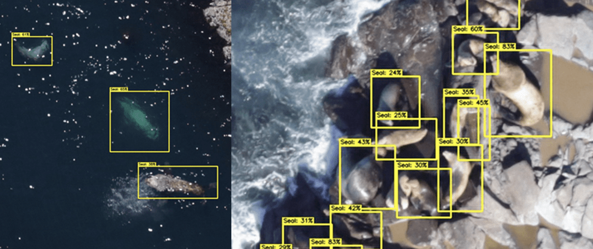
That grant supported a recently completed project, called SOUSAPHONE, which studied how software could enable multiple ship-launched unmanned aerial systems (UASs) to conduct semi-autonomous wildlife survey operations, and in particular, surveys of pinnipeds—the group of animals that includes walruses and seals. Scientists perform ground and air-based surveys to make careful observations of animal populations and characteristics, such as their health or behavioral patterns, collecting data that is critical to conservation efforts.
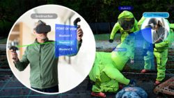
However, to use drones in the survey process, the researchers had to develop a system that can work within existing FAA regulations, which stipulate that operators must have a visual line of sight (VLOS) to their drone to reduce risk of accidents and collisions.
A grant awarded in June 2020 supports another project, called SCOUT, that explores how UASs can aid natural disaster relief efforts, such as by rapidly deploying to areas damaged by storms or wildfires and then transmitting information back to responders.
Unmanned systems are one of four NOAA science and technology focus areas described in its April 2020 Business Brief. Drones already provide—or are expected to provide—many unique capabilities to the agency, particularly for remote or dangerous areas.
Both of Charles Rivers’ efforts are led by Daniel Stouch, Director of Space & Airborne Systems, who has previously studied the use of drones for many defense-related applications and scenarios—but never for surveying seals.
“I’ve been learning a lot about environmental monitoring, the core NOAA missions, and how they’re performed,” Stouch said. During the SOUSAPHONE project, his team met on multiple occasions with NOAA biologists and zoologists who provided expert feedback on the research. “It’s been great to learn about these missions and the context in which our type of system would operate and be effective.”
A central challenge identified by Stouch and his team has been figuring out how to implement the best practices developed for current surveys—which use more traditional methods—with their advanced drone solutions.
“When NOAA does these animal surveys, they typically go back to the same places every year where they know there are lots of animals, and they count and characterize,” Stouch said. “If you go back and instead of 20% [of the population] being pups and juveniles, it’s only 5%, then that tells you something is wrong; there’s fewer breeding pairs for example, or there was a rough winter.”
So far, the researchers have proven that their software can detect seals, ships, and other drones, which will enable them to chain together the lines of sight from multiple drones and observe animals from beyond the direct human line of sight—potentially enabling a much sought after BVLOS (beyond VLOS) mode of operation. In future work, they plan to enhance their computer vision algorithms to classify different age categories of seals and perform live flight tests of the overall system.
This article was prepared by Charles River Analytics Inc. using Federal funds under award NA20OAR0210325 and award NA20OAR0210101 from the National Oceanic and Atmospheric Administration, U.S. Department of Commerce. The statements, findings, conclusions, and recommendations are those of the authors and do not necessarily reflect the views of the National Oceanic and Atmospheric Administration or the U.S. Department of Commerce.